Cold Creek
Info
Epic views, leg burning grinds, hero dirt all year, and a stupid grin on your face that you’ll need a plastic surgeon to remove, and if you live in Vancouver, you can have it all after work any day of the week. Less than 45 minutes from Vancouver and 1 hour from the East side of Portland, Cold Creek is the most heavily biked section of the Tarbell trail system, and is distinctive enough from the rest of the system that it deserves its own guide and write up. Locals typically ride this section after work, bringing lights in the winter, and tack it onto other parts of the Tarbell system or combine it with Thrillium, Bells Mountain, or Chinook for more epic weekend rides.
If you claim Cold Creek as your home trail, you’ll have the climbing chops to show for it, because there is no easy way up this hill. Cold Creek is the section of the Tarbell trail that parallels Cold Creek up the flanks of Larch Mountain. Riders can choose whether they want their climbing torture out in the open and at the beginning by climbing up a logging road that’s punishingly steep for the first mile, or get on with the grunt under trees after a nice, gentle warmup by choosing a pedal up known as Murphy’s Grade, which climbs gently under trees most of the way up the hill and proceeds to get serious about the climbing after the first mile and a half. Downhillers who couldn’t arrange a shuttle typically walk up the road, cross country and all mountain riders typically ride up Murphy’s grade. There is a third option that involves a partial shuttle up to the Thrillium trail parking lot, then a steep 1 mile pedal up past the gate and up the road to the top of Larch Mountain, then a rough and rocky descent down an old road grade strewn with baby heads to the rocky clearing called the Flintstones that usually marks the top for most rides climbing from the bottom.
The Cold Creek trail sits on some the best dirt in Washington. The surface is mostly packed Cascade Clay under the needles from top to bottom, with very occasional wet spots that are well drained by berms and culverts and an insanely active group of volunteers who keep this trail rideable essentially all year, so long as it’s not buried in snow. It’s mostly low elevation, with the bottom half rideable all year, and the top half typically open from late March through early December. The sections that descend through clear cuts are susceptible to loose surfaces during the driest months, but it’s not significant enough to affect the riding experience.
All mountain riders and even downhillers will really appreciate this line as it descends consistently with only a couple of very minor transitions that require minimal pedaling. Cold Creek is the closest mountain biking gets to feeling like a downhill ski run in late season, with little kickers everywhere there could possibly be a kicker, and nice little drops right where you need them so you can pick up speed. Experienced riders might even be able to avoid pedaling a lot of the transitions if they use the aerial features skillfully. This trail has benefited from 20 years of riding and digging, and 20 years of incremental improvements have added up to a uniquely rewarding experience. In short, this trail is all about flow.
Rollable obstacles abound, with the trail descending through multiple root falls, rock gardens, and over numerous natural features that keep you looking ahead and around every corner and sight line. The bike will not carry you down this line; you’ve got to ride it actively. You will be panting by the time you get to the bottom. This trail is what all mountain and enduro bikes are built for. But riders of hard tails and 120mm bikes need not fear. The trail builders have assiduously provided roll arounds for every significantly sized feature.
XC riders shouldn’t scoff at this trail, even though it looks short at only 3.3 miles from the parking area to the typical stopping point, which is a picnic table located in a field of dinner plate rocks. Keep in mind that the top of this trail is 2000 feet of climbing from the bottom. This is how you pack in the elevation training after work.
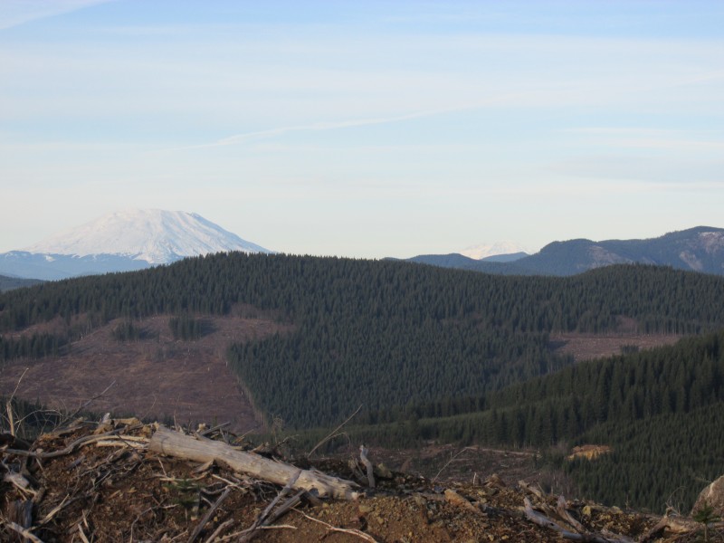
This trail rewards intrepid climbers with breathtaking views of Mount Saint Helens and Silver Star Mountain, which, at 4200 feet, looks decisively alpine and rugged as its flanks are treeless down to 2000 feet, a lingering result of the Yacolt Burn, the largest forest fire in Washington State history, which tore through this area in 1902.
This trail is maintained by the Cold Creek Mountain Bikers.
Photos
Videos
Trail Status
Ride Reports
I had to do some errands in Portland today, so I went down to Yacolt Burn State Forest and did the Thrillium Trail twice today. I had to clear two trees on run one and then had a great time on run two. The roots were a little...

