
Presenting the 2024 Dirty Dozen!
We present to you the 2024 Dirty Dozen, our 5th annual summer trail challenge! This is a virtual activity for you and your friends to get out and explore 12 new trails outside of your network, all across the state of Washington, highlighting the riding in each of our 8 regional chapters. And, while it’s not a contest or competition, those who complete each trail before December 31st, 2024 and record their rides using TrailForks will receive a 2024 Dirty Dozen Trailforks badge – as a virtual medal of honor.
UPDATE 8/14/2024:
OOPS. We got a bit over our bars on this one. We thought we could do a "ride 12 of 15 trails" but it turns out TrailForks doesn't support that. So we're back to a dozen, and hope to include Quartz Creek, Ticket to Ride, and Bob's Trail in future iterations of the DD.
2024 Dirty Dozen trails (as of 8/14/2024🤭):
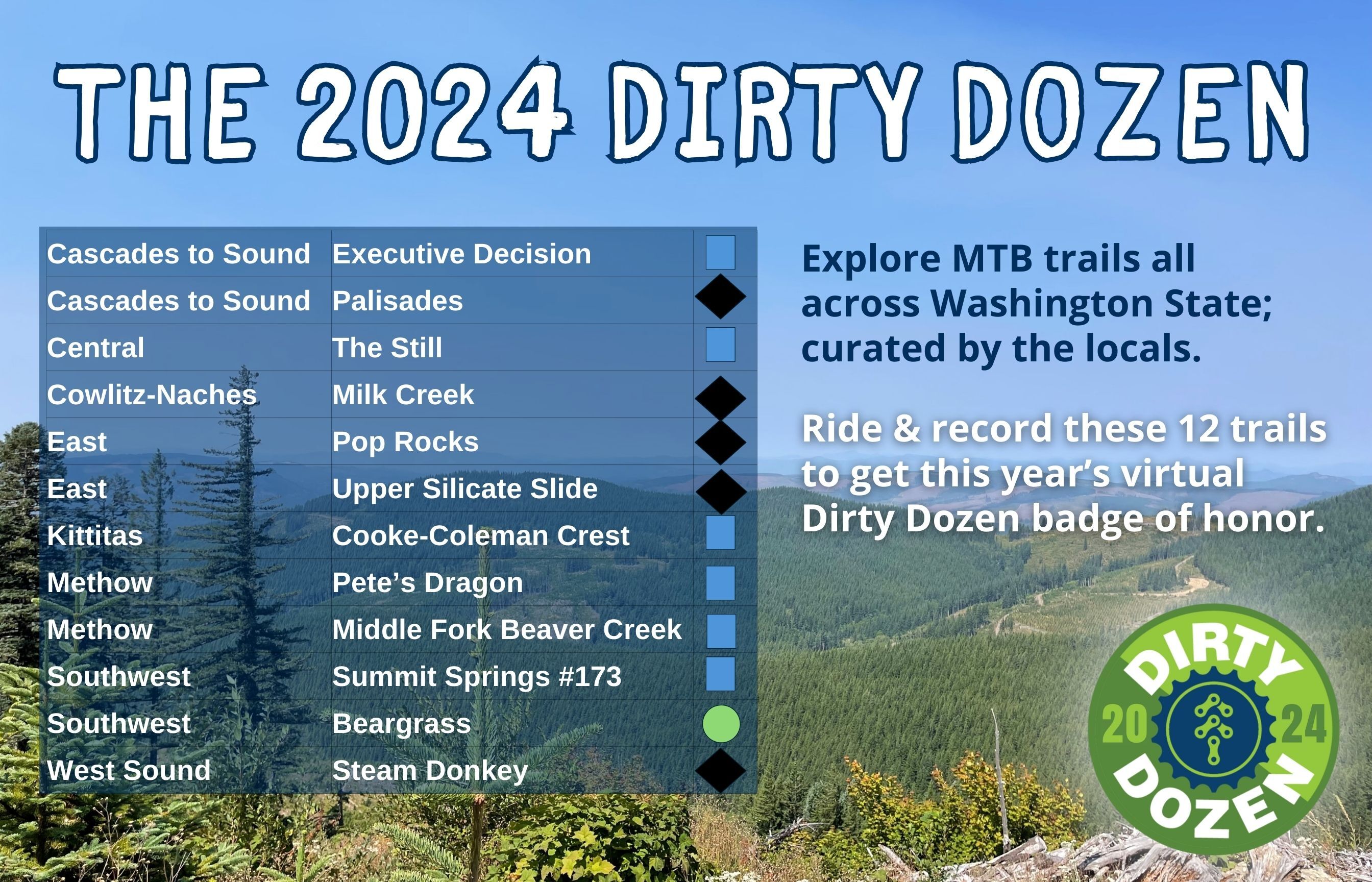
We sought nominations from all eight Evergreen chapters for great trails to ride. We’ve taken their nominations and curated a list of trails that encompasses the things they are stoked about. And this year we’re adding an extra feature: there are 15 trails nominated but you only need to ride 12. That way if you can’t get to a certain area, or don’t have a shuttle buddy, no worries!
The trails vary in difficulty; some are more strenuous or technical than others. But we’re confident that riders with a solid baseline of intermediate fitness, skills, and experience will be able to hit the trails, and take down this challenge head on. Some of the trails would be great to take the family on to build up skills, some are more in the epic category. Have fun and be creative with how you tackle this challenge. The point is to get you to areas where you wouldn’t usually go, on trails curated by the locals. Special thanks to volunteer Gordon Brandt!
Now, the 2024 Dirty Dozen awaits!
Remember to #RecreateResponsibly
Tag @EvergreenMTB in your photos on social media along with the hashtag #EvergreenDirtyDozen
Happy trails!
*Note: For trailhead parking information, visit TrailForks, search the trail, find the parking lot listed and click “drive directions.” 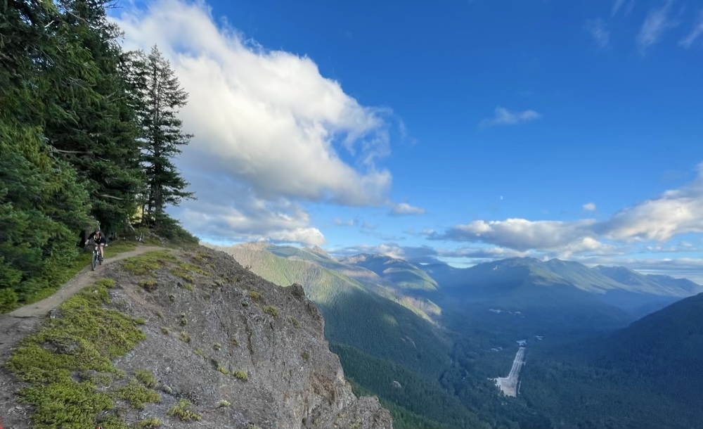
Trail Name: Palisades
https://www.trailforks.com/trails/palisades/
Distance: 6.1 miles down; 13.2 for the loop: https://www.trailforks.com/route/ranger-creek-and-palisades-loop/
Descent: 2880 ft
Difficulty Rating: Black
Trail Description: A classic in the 410 corridor with epic views. Usually ridden counterclockwise with Ranger Creek as the climb. Creeks, waterfalls, and incredible views from the cliffs.
Access: Typically done as a loop with Ranger Creek: Park near the White River Trail. Then ride the loop counterclockwise: White River Trail, up Ranger Creek, down Palisades, and back on White River Trail.
Trail Name: Executive Decision
https://www.trailforks.com/trails/executive-decision--kraus-d/
Distance: 0.9 mi
Descent: 417 ft
Difficulty Rating: Blue
Trail Description: New trail at Raging River opened June 2024. Really two trails in one: Upper sections are machine-built wide, buff, bermy & flowy that get faster and more jumpy as you work your way down. And they are brand new so get em before there are any bumps. Lower sections are rough raw hand-built and more technical but all rollable. This trail is named in honor of departing EMBA Exec Dir Yvonne Kraus.
Access: Raging Tiger Trail to Pacific Climbing Trail.
Trail Name: The Still
https://www.trailforks.com/trails/the-still/
Distance: 3.2 mi
Descent: 463 ft
Difficulty Rating: Blue
Trail Description: Beautiful hilltop ride above #2 canyon. Flowy, great views, gentle enough for a family ride.
Access: Go up #2 canyon (where the road is now fantastic), pass the first parking lot and go up to the upper parking lot. The upper road is rutted but passable by any car.
Trail Name: Milk Creek
https://www.trailforks.com/trails/milk-creek-154365/
Distance: 3.7 mi
Descent: 1740 ft
Difficulty Rating: Black
Trail Description: At Little Bald Mountain, Naches. Multi use trail so may see motos and horses. Per TF: Super fun decent that starts as a rough rocky trail in the forest and ends in a clay based moonscape that has many unique features.
Access: Climb or shuttle FR1708. The climb is about 2300 ft, 7.7 miles, average grade 6%. May be a good one to shuttle, which requires a high ground clearance vehicle.
Trail Name: Pop Rocks
https://www.trailforks.com/trails/pop-rocks/
Distance: 0.6 mi
Descent: 260 ft
Difficulty Rating: Blue
Trail Description: On Beacon Hill, outside Spokane. Super fun trail. Every few hundred yards is a new rock puzzle: go over, around, or through. Can be run as a black or blue depending on the line you take. Then you get to do the flowy Master Blaster and Scared Cat to get back to the bottom.
Access: Park in the Esmerelda golf course parking lot, climb Esmeralda trail to the radio towers.
Trail Name: Upper Silicate Slide
https://www.trailforks.com/trails/upper-silicate-slide/
Distance: 1.1 mi
Descent: 566 ft
Difficulty Rating: Black
Trail Description: For those who haven’t been to Mica Peak, it’s a gem. Dense pine forest with a creek running through. Upper Slide is the top of the mica flow trail. About 1700 ft climb to get to the entrance. A couple steep berms at the top, then flow, flow, flow. Next comes Lower Silicate Slide, then jog over to Cart Before the Horse. You may hurt yourself smiling.
Access: All Mica Peak trails accessed from parking lot on E. Belmont Road.
Trail Name: Cooke-Coleman Crest section 1
https://www.trailforks.com/trails/cookecoleman-crest-section-1/
Distance: 1.6 mi
Descent: 521
Difficulty Rating: Blue
Trail Description: A scenic ridge ride with a backcountry feel climbs through pine forests to a plateau with views of Mission Ridge to the north and the Kittitas Valley to the South. At the top of the ridge, you can turn and burn back to the bottom, enjoying over 4 miles of nearly continuous descent. If you want to extend your ride take a lap from the top of the knoll by going up Bucking Chute and down Hustler, or stretch out your legs on the XC loop (not a full loop yet but can be paired with the Up the Middle double track for a short loop). When you descend the Cooke-Coleman Crest keep an eye out for the alternate downhill routes (Kittitas Cadillac and 8 Second Ride) that bypass some of the switchbacks in favor of steeper and faster variations. Finish by dropping into one of the jump lines off of the power lines near the bottom to complete the ride back to the parking lot. If you have more time and energy, Basalt Flow is a fantastic green/blue flow trail that riders of all levels will enjoy. As a true backcountry experience, wildlife sightings (including herds of elk) are common on this ride. The tread is narrow in places and the trails are still in development so be alert for unexpected hazards.
Access: Can do as an out and back or shuttle or solo climbing Tyee Rd. Access via Cooke Canyon Rd.
Trail Name: Pete’s Dragon
https://www.trailforks.com/trails/pete-s-dragon/
Distance: 2.6 mi
Descent: 1000 ft
Difficulty Rating: Blue
Trail Description: Sun Mountain area in the Methow. Serpentine, fast, fun and flowy. Berms, drops, jumps all of which are rollable.
Access: From the Chickadee trailhead, ride up Climb It Change to NF4410 to Woodpecker. Or can shuttle up NF4410 from Patterson Lake Rd.
Trail Name: Middle Fork Beaver Creek
https://www.trailforks.com/trails/middle-fork-beaver-creek-trail/
Distance: 3.2 mi
Descent: 1053 ft
Difficulty Rating: Blue
Trail Description: Located in the Loup Loup/North Summit area, ride a great descent with fun, flowing and fast singletrack that starts in dense forest and descends down towards Beaver Creek.
Access: From US20, take NF42 then FS4225 to the parking lot at the base of the trail. About 4 mi climb on FS 4225 and FS 4230 to the entrance.
Trail Name: Summit Springs (aka #173)
https://www.trailforks.com/trails/summit-springs/
Distance: 3.1 mi
Descent: 1857 ft
Difficulty Rating: Blue
Trail Description: In Silver Star Scenic Area, North Bonneville WA. Raw, beautiful, sparsely ridden deep forest singletrack.
Access: WA 503 to NE Sunset Falls Rd to the parking area. Then ride or shuttle about 5.3 mi / 2300 ft up NF41/4014. Or some ride it as an out and back, which means pushing up much of the trail.
Trail Name: Bear Grass
https://www.trailforks.com/trails/beargrass/
Distance: 1.5 mi
Descent: 523 ft
Difficulty Rating: Green
Trail Description: In Yacolt Burn. A connector between Larch Mountain TH parking and Tarbell. Can be used as access to Cold Creek / Sixth Sense making a loop of about 11 miles and 2300 ft climbing. Great trail for skills progression.
Access: From Larch Mountain TH or from Dole Valley road TH. One route would be starting in Dole Valley Rd, Murphy’s Grade, 1070 Rd / L1050 Rd, Aaron’s Climbing Trail. Then Beargrass to Cold Creek.
Trail Name: Steam Donkey
https://www.trailforks.com/trails/steam-donkey-661481/
Distance: 0.3 mi
Descent: 135 ft
Difficulty Rating: Black
Trail Description: One of the newer runs at the north end of Port Gamble. Fast and flowy DH track.
Access: Highway 104 to trailhead parking lot, then Ewok Climb Trail and access roads.